
Geocadastre | geological surveys
Le cadastre cantonal des sondages géologiques – a web portal for consulting and editing subsoil data for the Canton of Valais
Launched at the end of 2013, Géocadastre – the cantonal geological survey cadastre – has gradually established itself as a reference tool for practitioners. The Geocadast web portal not only enables consultation of subsurface data, but also provides information on the cantonal cadastre.
The quaternary data contained in the Geocadastre are used and valorized in various projects in which CREALP is directly involved. More information is available at Dépôts Quaternaires.
Access to the Geocadastre
Any stakeholder in a project involving geological surveys can request a user account (Request an account) to contribute to the cadastre. No account parameters are required for data consultation.
Access to the Geocadastre
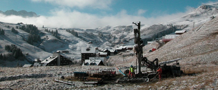
The demographic and economic growth seen in the Valais over the last few decades has had an impact on the organization of our territory. Today, underground space is a source of multiple challenges, whether in terms of natural resource management, environmental management or urban development. In this respect, knowledge and study of the subsoil are of paramount importance, and data from geological surveys is an essential source of information.

It was against this backdrop that the Canton of Valais decided to set up a computerized geological cadastre to record drillings carried out throughout its territory. To this end, it decided to join the inter-cantonal collaboration initiated by the Canton of Vaud, aimed at pooling skills and resources to implement a common IT solution for managing borehole data.
Operational since the end of 2013, the tool has been designed to operate in a collaborative mode, with the aim of actively involving potential contributors in updating the database. The geological cadastre is presented as a web application(Geocadast) offering different levels of access depending on the type of user and information concerned:
Free public access for data consultation
Consultation of the geological cadastre is open to the public, and enables borehole data to be viewed geographically via the Geocadast web application. Data can be searched via a dynamic map, or in a more targeted way, using a search by criterion via a query engine. In both cases, detailed survey data can be consulted (Firefox browser recommended). To learn how to use the application, please refer to the user manual.
Restricted access for contributors to edit new data
The quality and viability of the geological cadastre depends to a large extent on the voluntary participation and dedication of contributors. In order to facilitate survey data entry and optimize data quality via the Geocadast web application, a user manual, as well as other documents and frequently asked questions, are available to contributors. The main steps are described on this page.
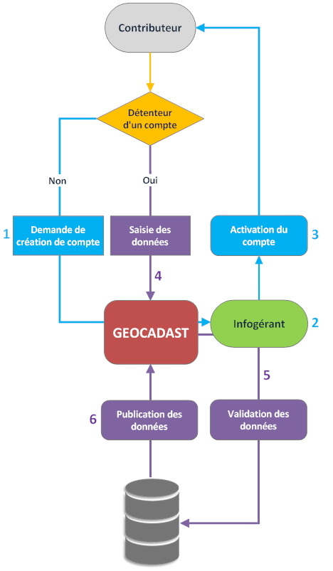
- The new user applies for an account with the land registry operator;
- The geological cadastre manager evaluates the request;
- Once the account request has been validated, the account is activated;
- Contributors can then enter their data via the Geocadast application (user manual);
- Newly-edited data is reviewed and validated by the land registry’s data manager;
- Once validated, these data are published online via the Geocadast web platform.
FREQUENTLY ASKED QUESTIONS (FAQ)
What is a geocadastre?
The geocadastre (or cadastre of geological soundings) is a bank of subsoil information. More concretely, it takes the form of a database that records information from geological boreholes, such as the nature and arrangement of rocks and soils (thickness and succession of layers), hydrological characteristics (depth and quality of groundwater), as well as information relating to the borehole itself (date, location, type, purpose, equipment, operator, etc.).
What is Geocadast?
Geocadast is theweb application used to view and enter borehole data into the cadastral database of geological boreholes. Initiated and developed by the Canton of Vaud, it has since been adopted by the cantons of Jura, Thurgau and Valais, who also use it to manage their respective cadastres. The application is based on a collaborative approach.
What can I actually do with the Geocadast web application?
This application offers two levels of use: a first level of free access and a second level of editing for professionals. In “consultation” mode, geographical visualization and searches by criteria can be carried out throughout the Canton of Valais. The “edition” mode allows practitioners to edit, search and extract data. This mode is reserved for contributors with secure access parameters (account request).
Who can fill in the geocadastre?
Any stakeholder in a project involving geological surveys can request a user account from the land registry administrator (account request). Once the request has been approved, the future contributor will receive secure account parameters.
Is it compulsory to announce a survey in the geocadastre?
No. For the moment, there is no legal framework for the geocadastre. However, an obligation to provide cadastral information will probably soon be required by the Canton (it is already compulsory in the Canton of Vaud, for example).
Why is it important to contribute to the geocadastre?
Today, underground space is a source of multiple challenges, whether in terms of natural resource management, environmental management or urban development. As geological cadastral information is not yet compulsory in the Canton of Valais, voluntary and active participation is essential for optimum knowledge of the subsoil. A complete geological cadastre will thus make an effective contribution to reducing environmental and natural risks, while enabling a more sustainable approach to construction and land use planning.
What types of soundings are included in the geocadastre?
Any borehole that provides geological information about the subsoil can be integrated into the geocadastre. Data can be derived from direct boreholes (e.g. drilling, excavation, etc.) or indirect boreholes (e.g. geophysical or penetrometer surveys).
What kind of information can I obtain from the geocadastre?
All information relating to the survey. This information may vary depending on the purpose of the survey. It generally includes geological, hydrological, geographical, technical and administrative information.
Are the original surveys available?
Yes, Geocadast presents a detailed borehole record and offers the option of downloading the original borehole survey (mentioned as a document attached to the borehole). Documents related to the zone, i.e. to the entire study concerned, are sometimes also available.
How do I add data to the land register?
The “For contributors” section provides an overview of the steps involved in providing information to the geocadastre. In brief, the first step is to register for the cadastre by requesting an account. Once the account parameters have been obtained, the user can log in via theGeocadast application and enter his or her own data. A user manual, available in the “Documentation” section, provides a detailed description of the application if required.
Why do I need to apply for an account?
While one of the great qualities of the geocadastre is that it can be consulted online and accessed freely, data entry is reserved for professionals with an account. Once the data has been entered, a quality control check is carried out by the cadastre’s information manager(Thierry Nendaz and Pascal Ornstein). Once the data has been validated, it is published online. This secure publishing method ensures data quality and protection. Each contributor is responsible for the quality of their data and the confidentiality of their account settings.
Can other contributors modify my data?
No, the contributor can only modify his own data. This is until the data has been validated by the outsourcer. After this period, the contributor can no longer modify his data. They may, however, contact the administrator for any other modifications or updates to their data.
Why is some survey data marked confidential?
Contributors can request confidentiality of their data by contacting the administrator. In principle, only drilling for the commercial exploitation of natural resources (i.e. exploitation of hydrocarbons, geomaterials and mineral waters) can be the subject of a confidentiality request.
Information

PASCAL ORNSTEIN
Responsable de filière Expert en hydrogéo-informatique
Project duration: 2013 – ongoing
Project sponsor: Canton of Valais
Documentation & support
Below you’ll find various documents to help you get started with the geological cadastre and enter your data.
Documents to download
User manual (version 1.10)
Survey export: Microsoft Excel file with ArcGIS-compatible text field labels
Horizon import: Microsoft Excel file (with example) for direct import of a series of different horizons from a survey. The information relating to the various columns is as follows:
- Column A = Geotype code,
- Column B = Depth in metres to the base of each horizon,
- Column C = Lithology (text),
- Column D = Standard SN 670009,
- Column E = USCS code,
- Column F = Lithologies according to the Geological Atlas of Switzerland 1:25,000 (AG25),
- Column G = Stratigraphy / remarks / comments
Grades of foundation soil according to SIA 261
Request an account
Offices and companies wishing to enter data but who do not yet have an account are invited to request one via the form.
An account is only required for users who contribute to the geological cadastre, i.e. who announce boreholes, enter data or extract borehole data. Data consultation does not require an account.
Outsourcing
If you have any difficulties using the Geocadast application, or if you have any questions about the geological cadastre, please do not hesitate to contact us.