
Matterock methodology
A methodology for monitoring cliffs and detecting potential major landslides
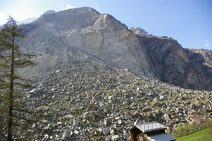
The major rockfall at Randa (Valais, Switzerland) in the spring of 1991 (30 Mom3) highlighted the scientific shortcomings in predicting such catastrophic events. It was therefore decided to develop a cliff monitoring methodology that would provide a better understanding of the phenomenon of cliff instability and anticipate potential rockfalls. This methodology, called MATTEROCK, was developed as part of the National Research Program PNR31 “Climate change and natural disasters” launched in 1992 by the Swiss NationalScience Foundation (SNSF). A second phase began in 2000. This time as part of a cross-border cooperation program: Interreg II C “Prevention of cliff movements and instabilities”. Funded by the SNSF and the canton of Valais, this new phase of the MATTEROCK project aimed to improve rockfall detection tools, in particular by exploring the possibilities offered by geomechanical analysis.

The MATTEROCK methodology is based on the premise that there can be no rockfall without discontinuities (faults, schistosity, etc.). The first step is to analyze and define the cliff’s structural layout by characterizing families of discontinuities. The structural layout is then compared with the topographic surface to identify cliff compartments (hazards) prone to sliding and/or tilting (automated with Matterocking). A hazard index qualifying the probability of failure is then assigned to each compartment according to its intrinsic factors (petrographic, lithological, structural and geomechanical characteristics), its sensitivity to external degradation processes (erosion, minor earthquakes, etc.) and to triggering situations (extreme physical conditions). Finally, hazard maps are drawn up on the basis of these hazards.
The hazard map is an indispensable tool for risk managers and land-use planners in mountain regions. The degree of hazard is generally qualified by the intensity and probability of occurrence of a catastrophic event. However, the particularity of a rockfall is that it is very rarely reproducible, unlike a flood event, for example. For this reason, MATTEROCK relegates the notion of occurrence to the background and relies primarily on a definition of the degree of danger, which considers not only the intensity of the phenomenon, but also the probability of the hazard breaking down and the probability of the object to be protected (homes, communication routes, etc.) being affected. By the end of the2nd phase of the project, the MATTEROCK methodology had been applied to over 50 sites in Valais, notably in the Mattertal, Saastal and Simplon Valleys, in the Val de Bagnes, and in Italy.
The latest recommendations published by the FOEN(FOEN, 2016) consider that 6% to 8% of Swiss territory is affected by ground movements, which include landslides, mudflows and rockfalls in particular. In addition, the increase in bad weather in recent years has destabilized certain slopes that had never been reported or assessed as potentially unstable. The notion of climate change put forward by PNR31 in the early 90s now seems to be taking on its full significance.
Matterocking
Estimating the average number of discontinuities on a digital topographic surface
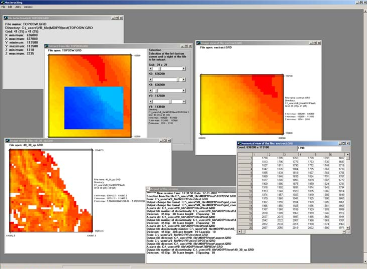
Matterocking software has been designed to estimate the average number of discontinuities on a digitized topographic surface.
Using a digital terrain model (DTM), Matterocking compares structural data from field investigations (orientation and persistence of discontinuities) with the orientation of the topographic surface. This enables us to estimate the average number of discontinuities intersecting the relief, and to identify areas where rock instabilities may be produced by discontinuities or dihedrals over which rock slides are possible.
Various functionalities are implemented, such as the estimation of potential landslide surfaces, the number of surfaces and the linear number of surfaces within a DTM cell. However, as Matterocking is a calculation-only software package, it is necessary to use an external visualization tool to obtain a cartographic view of the results (ArcGIS, QGIS, etc.).
Information
Project manager :

PASCAL ORNSTEIN
Responsable de filière Expert en hydrogéo-informatique
Project duration :
Project sponsors: Swiss National ScienceFoundation (SNSF) & Canton of Valais
Download and support
Software
Matterocking
Updated January 14, 2003
- Version 2.0 (executable)
Visual Basic runtime (to be installed before MatterCliff)
- VB6 version (executable)
Documentation
User manual (English)
Updated January 14, 2003
Further information

Baillifard, F. J. (2004). GIS detection of rocky areas with high rockfall susceptibility. University of Lausanne.
Baillifard, F., Jaboyedoff, M., Rouiller, J. D., & Tosoni, D. (2001). Matterock. In Prévention des mouvements de versants et des instabilités de falaises. Confrontation des méthodes d’étude des éboulements rocheux dans l’arc alpin. Programme Interreg II C – ” Falaises ” Méditerranée Occidentale et Alpes Latines (p. 70-79).
Baillifard, F., Jaboyedoff, M., & Sartori, M. (2003). Rockfall hazard mapping along a mountainous road in Switzerland using a GIS-based parameter rating approach. Natural Hazards and Earth System Science, 3(5), 435-442.
Jaboyedoff, M., Philippossian, F., Mamin, M., Marro, C., & Rouiller, J.-D. (1996). Spatial distribution of discontinuities in a cliff: Statistical and probabilistic approach. vdf Hochschulverlan.
Jaboyedoff, M., Baillifard, F., Marro, C., Philippossian, F., & Rouiller, J.-D. (1999). Detection of rock instabilities: Matterock methodology. Joint Japan-Swiss Scientific on Impact Load by Rock Falls and Protection Structures, 37-43.
Jaboyedoff, M., Baillifard, F., Philippossian, F., & Rouiller, J.-D. (2004). Assessing fracture occurrence using” weighted fracturing density”: A step towards estimating rock instability hazard. Natural Hazards and Earth System Science, 4(1), 83-93.
Jaboyedoff, M., Ornstein, P., & Rouiller, J.-D. (2004). Design of a geodetic database and associated tools for monitoring rock-slope movements: The example of the top of Randa rockfall scar. Natural Hazards and Earth System Science, 4(2), 187-196.
Marro, C., & Rouiller, J.-D. (1996). Case study of a cliff-type building zone-hazard conflict. In Die geologische Berarbeitung von Naturgefahren, erläutert an ausgewählten Fallbeispielen.
Ornstein, P., Jaboyedoff, M., & Rouiller, J. D. (2001). Geodetic monitoring of the Randa site (VS): Management of 1-D and 3-D measurements. Société Suisse de Mécanique des Sols et des Roches, 143, 82-91.
Interreg II Program (2001). Prevention of slope movements and cliff instabilities: Confrontation of rockfall study methods in the Alpine arc. Programme INTERREG IIC ” Falaises “, Méditérannée Occidentale et Alpes Latines. Interreg II.
Rouiller, J.-D. (1992). Randa rockfall. Strasse und Verkehr, 5, 373-376.
Rouiller, J.-D., & Marro, C. (1997). Application of the “MATTEROCK” methodology to cliff hazard assessment. Eclogae Geologicae Helvetiae, 90(3), 393-399.
Rouiller, J.-D., & Rey, J.-M. (1992). Les instabilités de terrains dans l’arc alpin. Bulletin de la Murithienne, 110, 97-110.
Rouiller, J. D., Jaboyedoff, M., Marro, C., & Philippossian, F. (1997). Matterock: Methodology for studying cliff instabilities and assessing danger. Société Suisse de Mécanique des Sols et des Roches, 7(1997), 13-16.
Rouiller, J.-D., Jaboyedoff, M., Marro, C., Philippossian, F., & Mamin, M. (1998). Unstable slopes in the Pennique valaisan: Matterock: a methodology for cliff auscultation and detection of potential major rockfalls (p. 239) [Final report of NRP31]. vdf Hochschulverlag AG.
Sartori, M., Baillifard, F., Jaboyedoff, M., & Rouiller, J.-D. (2003). Kinematics of the 1991 Randa rockslides (Valais, Switzerland). Natural Hazards and Earth System Science, 3(5), 423-433.
The final reports of the NRP 31 and Interrreg II C projects are available from CREALP | Contact.