
HyFORS
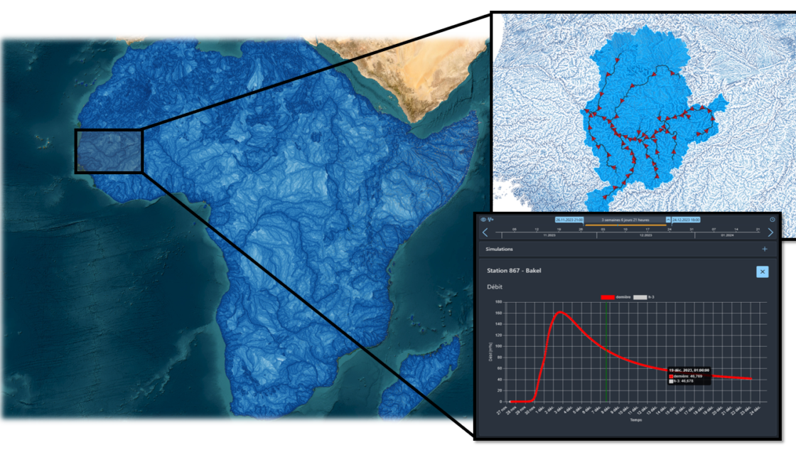
Hydrological Forecasting Online with Routing System HyFORS is a cloud platform that makes the adoption of operational hydrological/hydraulic forecasting systems accessible anywhere in the world with limited resources. By using global weather datasets and automating the creation and deployment of a complex operational system on Google Cloud Platform, this solution will help reduce hydrological risks and better manage water resources. A plug-and-play cloud platform for global flood forecasting In its 2022 Global… Read More
GUARDAVAL monitoring system
The Canton of Valais natural hazard monitoring portal Guardaval is a comprehensive IT platform for operational and synoptic monitoring of natural hazards (ground instabilities, floods, glacial hazards, meteorological hazards, debris flows, etc.) in the Valais. For over 20 years, CREALP has been maintaining and developing this constantly evolving platform for the State of Valais, integrating more data and functionalities every day. Today, Guardaval integrates more than 70 data sources from different suppliers… Read More
Spatial Reference Information System | Floods
A Spatially Referenced Information System for managing hydrological hazards in the canton of Valais SIRS-CRUES is one of a series of spatially referenced information systems (SIRS) set up by the canton of Valais to optimize the use and enhancement of information contained in natural hazard studies (avalanches, floods, ground instabilities). SIRS-CRUES records information relating to hydrological hazards. Developed on the initiative of the Natural Hazards Service(SDANA) and with the collaboration of the… Read More
Spatial Reference Information System | Geological Hazards
A Spatially Referenced Information System for managing geological hazards in the canton of Valais SIRS-DAGEO is one of the spatially referenced information systems (SIRS) set up by the canton of Valais to optimize the use and development of information contained in natural hazard studies (avalanches, floods, ground instabilities). SIRS-DAGEO records information relating to geological hazards. Launched by the canton of Valais in 2004, SIRS-DAGEO enables data from geological hazard studies to be… Read More
GIS Groundwater
Design and implementation of a Groundwater Information and Management System to enhance the value of cantonal subsurface data In close collaboration with the Service de l’environnement(SEN) – Groupe Eaux souterraines du Canton du Valais, CREALP has been involved in setting up a global strategy for groundwater monitoring in the short, medium and long term. This analysis, which considers the various aspects related to groundwater management (quantitative and qualitative monitoring, protection of water… Read More